Land area by US state

Summary

Land area, US states

Land area by state · all 52 states · hover or tap a state for every figure on this page

52 items
View100%
DownloadPDFImageCSV
StatesAlaska
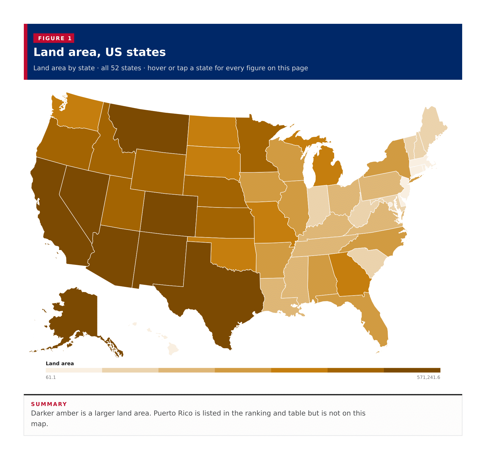
Land area, US statesDarker amber is a larger land area. Puerto Rico is listed in the ranking and table but is not on this map.Alabama · Land area: 50,651.0 · Water area: 1,769.0 · Total area: 52,420.1Alaska · Land area: 571,241.6 · Water area: 94,483.3 · Total area: 665,724.9Arizona · Land area: 113,655.4 · Water area: 329.7 · Total area: 113,985.1Arkansas · Land area: 51,991.9 · Water area: 1,205.7 · Total area: 53,197.6California · Land area: 155,859.2 · Water area: 7,834.6 · Total area: 163,693.8Colorado · Land area: 103,637.1 · Water area: 457.7 · Total area: 104,094.9Connecticut · Land area: 4,842.5 · Water area: 701.2 · Total area: 5,543.7Delaware · Land area: 1,948.5 · Water area: 540.2 · Total area: 2,488.8Florida · Land area: 53,654.8 · Water area: 17,748.7 · Total area: 71,403.5Georgia · Land area: 57,716.8 · Water area: 1,706.3 · Total area: 59,423.0Hawaii · Land area: 6,422.6 · Water area: 4,547.3 · Total area: 10,969.9Idaho · Land area: 82,645.4 · Water area: 923.2 · Total area: 83,568.5Illinois · Land area: 55,513.1 · Water area: 2,400.3 · Total area: 57,913.4Indiana · Land area: 35,825.1 · Water area: 596.1 · Total area: 36,421.3Iowa · Land area: 55,853.7 · Water area: 419.1 · Total area: 56,272.7Kansas · Land area: 81,758.6 · Water area: 519.6 · Total area: 82,278.2Kentucky · Land area: 39,485.4 · Water area: 920.5 · Total area: 40,405.9Louisiana · Land area: 43,212.9 · Water area: 9,162.5 · Total area: 52,375.4Maine · Land area: 30,845.1 · Water area: 4,534.8 · Total area: 35,379.9Maryland · Land area: 9,710.9 · Water area: 2,694.9 · Total area: 12,405.9Massachusetts · Land area: 7,801.0 · Water area: 2,753.2 · Total area: 10,554.1Michigan · Land area: 56,611.0 · Water area: 40,102.3 · Total area: 96,713.2Minnesota · Land area: 79,631.6 · Water area: 7,311.7 · Total area: 86,943.3Mississippi · Land area: 46,924.6 · Water area: 1,511.3 · Total area: 48,435.9Missouri · Land area: 68,746.4 · Water area: 960.4 · Total area: 69,706.8Montana · Land area: 145,550.3 · Water area: 1,493.0 · Total area: 147,043.3Nebraska · Land area: 76,815.0 · Water area: 532.4 · Total area: 77,347.4Nevada · Land area: 109,860.4 · Water area: 710.4 · Total area: 110,570.8New Hampshire · Land area: 8,953.8 · Water area: 396.1 · Total area: 9,349.9New Jersey · Land area: 7,354.9 · Water area: 1,364.2 · Total area: 8,719.2New Mexico · Land area: 121,312.7 · Water area: 280.5 · Total area: 121,593.2New York · Land area: 47,123.4 · Water area: 7,435.1 · Total area: 54,558.5North Carolina · Land area: 48,624.2 · Water area: 5,194.4 · Total area: 53,818.6North Dakota · Land area: 68,994.3 · Water area: 1,704.6 · Total area: 70,698.8Ohio · Land area: 40,858.9 · Water area: 3,966.9 · Total area: 44,825.8Oklahoma · Land area: 68,596.7 · Water area: 1,302.4 · Total area: 69,899.1Oregon · Land area: 95,996.7 · Water area: 2,381.8 · Total area: 98,378.5Pennsylvania · Land area: 44,742.1 · Water area: 1,311.8 · Total area: 46,053.9Rhode Island · Land area: 1,033.9 · Water area: 511.1 · Total area: 1,545.0South Carolina · Land area: 30,064.1 · Water area: 1,959.4 · Total area: 32,023.5South Dakota · Land area: 75,807.9 · Water area: 1,307.9 · Total area: 77,115.9Tennessee · Land area: 41,224.3 · Water area: 905.5 · Total area: 42,129.9Texas · Land area: 261,258.6 · Water area: 7,340.4 · Total area: 268,599.1Utah · Land area: 82,595.7 · Water area: 2,302.4 · Total area: 84,898.1Vermont · Land area: 9,217.3 · Water area: 397.9 · Total area: 9,615.2Virginia · Land area: 39,481.4 · Water area: 3,293.4 · Total area: 42,774.8Washington · Land area: 66,455.4 · Water area: 4,845.2 · Total area: 71,300.7West Virginia · Land area: 24,041.2 · Water area: 188.8 · Total area: 24,230.0Wisconsin · Land area: 54,168.0 · Water area: 11,328.7 · Total area: 65,496.7Wyoming · Land area: 97,088.6 · Water area: 721.2 · Total area: 97,809.8District of Columbia · Land area: 61.1 · Water area: 7.2 · Total area: 68.4District of Columbia · Land area: 61.1 · Water area: 7.2 · Total area: 68.4Land area61.1571,241.6
Summary

Darker amber is a larger land area. Puerto Rico is listed in the ranking and table but is not on this map.

Alaska is the largest published area at 571,242 square miles of land, about 16 percent of the land in the 50 states and more than 550 times the land of Rhode Island, the smallest of the 50 states at 1,034 square miles. Texas is second at 261,259 square miles, then California at 155,859. Eight states reach 100,000 square miles of land. A typical published area has 52,823 square miles, the midpoint of the 50 states, the District of Columbia and Puerto Rico on the 2024 Census gazetteer. The District of Columbia is the smallest published area at 61.1 square miles. These are each area's own land area, not a United States total: the 50 states together cover about 3,533,406 square miles of land.

In short

571,242 sq miAlaskalargest land area
1,034 sq miRhode Islandsmallest of the 50 states
61.1 sq miDistrict of Columbiasmallest published area
52,823 sq mitypical published areathe middle area, not a US total
8states at or above 100,000 sq miAlaska, Texas, California, Montana, New Mexico, Arizona, Nevada and Colorado
Figure 1

Land area, all published states

Land area · all 52 · ranked high to low

52 items
View100%
DownloadPDFImageCSV
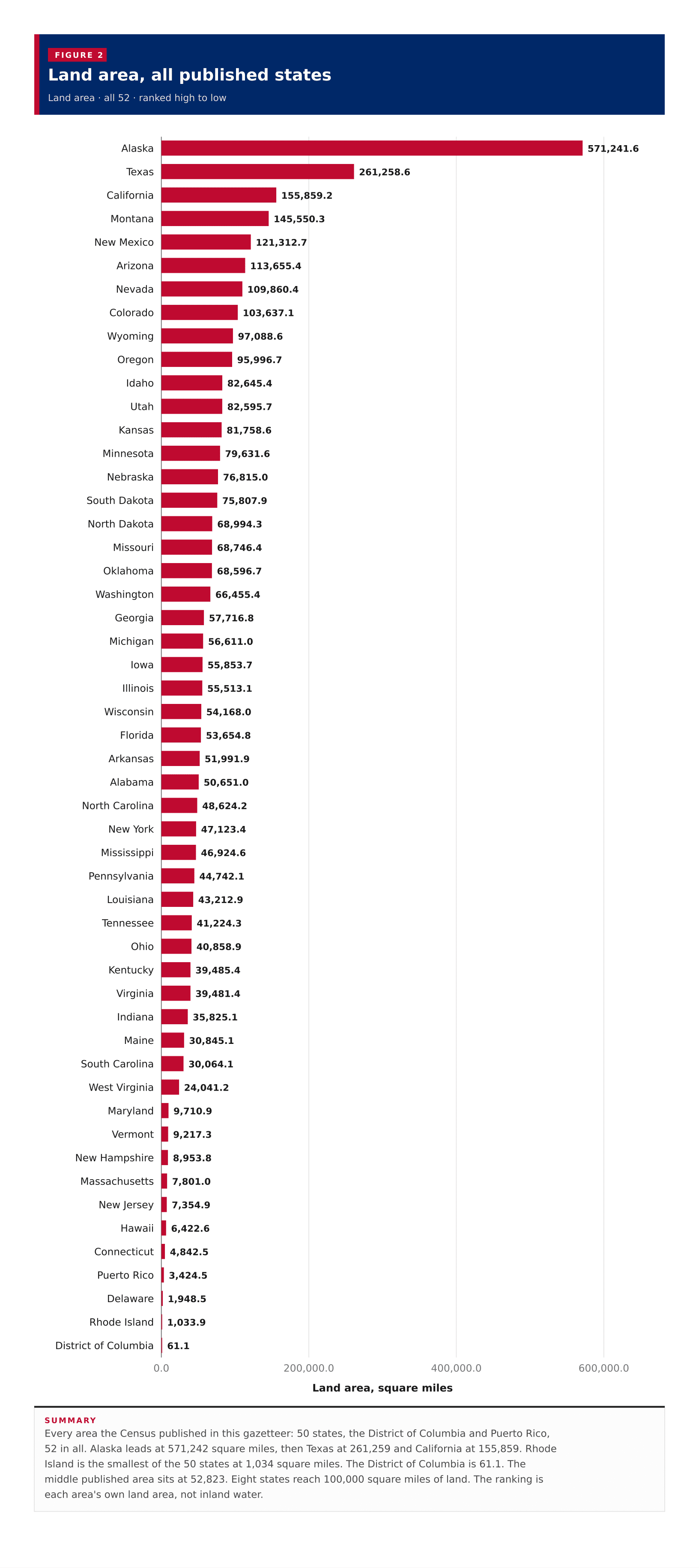
Land area, all published statesEvery area the Census published in this gazetteer: 50 states, the District of Columbia and Puerto Rico, 52 in all. Alaska leads at 571,242 square miles, then Texas at 261,259 and California at 155,859. Rhode Island is the smallest of the 50 states at 1,034 square miles. The District of Columbia is 61.1. The middle published area sits at 52,823. Eight states reach 100,000 square miles of land. The ranking is each area's own land area, not inland water.0.0200,000.0400,000.0600,000.0Land area, square miles571,241.6Alaska261,258.6Texas155,859.2California145,550.3Montana121,312.7New Mexico113,655.4Arizona109,860.4Nevada103,637.1Colorado97,088.6Wyoming95,996.7Oregon82,645.4Idaho82,595.7Utah81,758.6Kansas79,631.6Minnesota76,815.0Nebraska75,807.9South Dakota68,994.3North Dakota68,746.4Missouri68,596.7Oklahoma66,455.4Washington57,716.8Georgia56,611.0Michigan55,853.7Iowa55,513.1Illinois54,168.0Wisconsin53,654.8Florida51,991.9Arkansas50,651.0Alabama48,624.2North Carolina47,123.4New York46,924.6Mississippi44,742.1Pennsylvania43,212.9Louisiana41,224.3Tennessee40,858.9Ohio39,485.4Kentucky39,481.4Virginia35,825.1Indiana30,845.1Maine30,064.1South Carolina24,041.2West Virginia9,710.9Maryland9,217.3Vermont8,953.8New Hampshire7,801.0Massachusetts7,354.9New Jersey6,422.6Hawaii4,842.5Connecticut3,424.5Puerto Rico1,948.5Delaware1,033.9Rhode Island61.1District of Columbia
Summary

Every area the Census published in this gazetteer: 50 states, the District of Columbia and Puerto Rico, 52 in all. Alaska leads at 571,242 square miles, then Texas at 261,259 and California at 155,859. Rhode Island is the smallest of the 50 states at 1,034 square miles. The District of Columbia is 61.1. The middle published area sits at 52,823. Eight states reach 100,000 square miles of land. The ranking is each area's own land area, not inland water.

Figure 2

Water area, all published states

Water area · all 52 · ranked high to low

52 items
View100%
DownloadPDFImageCSV
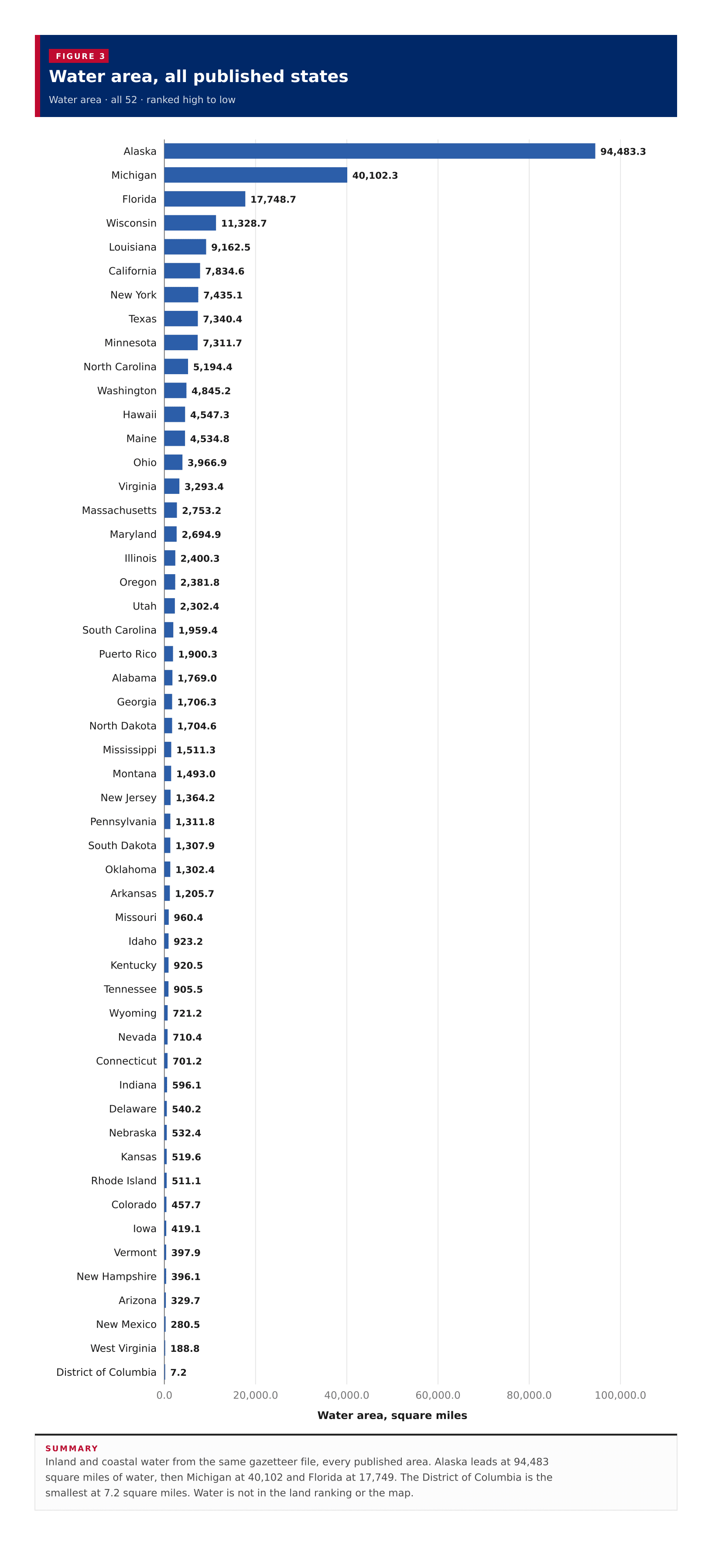
Water area, all published statesInland and coastal water from the same gazetteer file, every published area. Alaska leads at 94,483 square miles of water, then Michigan at 40,102 and Florida at 17,749. The District of Columbia is the smallest at 7.2 square miles. Water is not in the land ranking or the map.0.020,000.040,000.060,000.080,000.0100,000.0Water area, square miles94,483.3Alaska40,102.3Michigan17,748.7Florida11,328.7Wisconsin9,162.5Louisiana7,834.6California7,435.1New York7,340.4Texas7,311.7Minnesota5,194.4North Carolina4,845.2Washington4,547.3Hawaii4,534.8Maine3,966.9Ohio3,293.4Virginia2,753.2Massachusetts2,694.9Maryland2,400.3Illinois2,381.8Oregon2,302.4Utah1,959.4South Carolina1,900.3Puerto Rico1,769.0Alabama1,706.3Georgia1,704.6North Dakota1,511.3Mississippi1,493.0Montana1,364.2New Jersey1,311.8Pennsylvania1,307.9South Dakota1,302.4Oklahoma1,205.7Arkansas960.4Missouri923.2Idaho920.5Kentucky905.5Tennessee721.2Wyoming710.4Nevada701.2Connecticut596.1Indiana540.2Delaware532.4Nebraska519.6Kansas511.1Rhode Island457.7Colorado419.1Iowa397.9Vermont396.1New Hampshire329.7Arizona280.5New Mexico188.8West Virginia7.2District of Columbia
Summary

Inland and coastal water from the same gazetteer file, every published area. Alaska leads at 94,483 square miles of water, then Michigan at 40,102 and Florida at 17,749. The District of Columbia is the smallest at 7.2 square miles. Water is not in the land ranking or the map.

Figure 3

Land area against water area

Water area against land area · one point per row, 52 of 52 plotted

52 items
View100%
DownloadPDFImageCSV
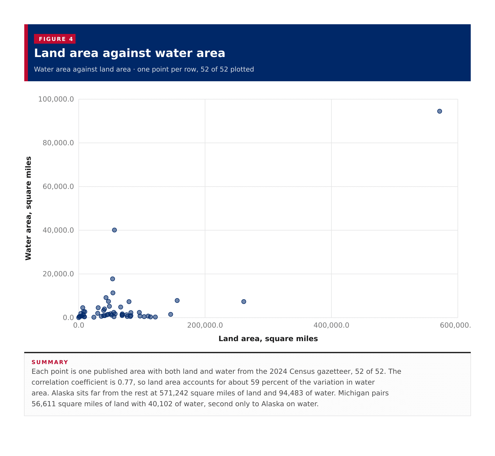
Land area against water areaEach point is one published area with both land and water from the 2024 Census gazetteer, 52 of 52. The correlation coefficient is 0.77, so land area accounts for about 59 percent of the variation in water area. Alaska sits far from the rest at 571,242 square miles of land and 94,483 of water. Michigan pairs 56,611 square miles of land with 40,102 of water, second only to Alaska on water.0.020,000.040,000.060,000.080,000.0100,000.00.0200,000.0400,000.0600,000.0Water area, square milesLand area, square miles
Summary

Each point is one published area with both land and water from the 2024 Census gazetteer, 52 of 52. The correlation coefficient is 0.77, so land area accounts for about 59 percent of the variation in water area. Alaska sits far from the rest at 571,242 square miles of land and 94,483 of water. Michigan pairs 56,611 square miles of land with 40,102 of water, second only to Alaska on water.

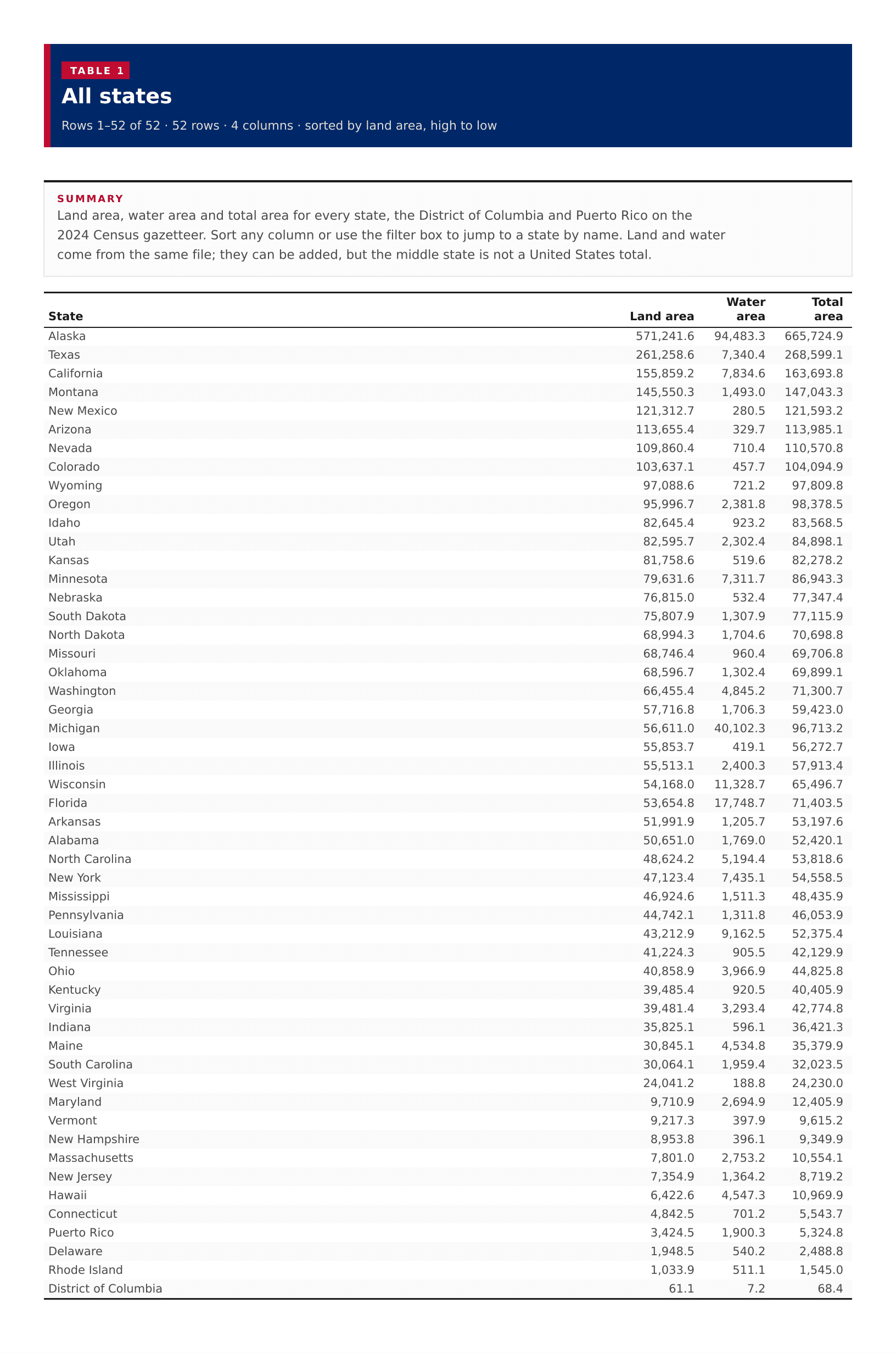
Table 1

All states

52 rows · 4 columns · sorted by land area, high to low

52 rows
View100%
DownloadPDFImageCSV
Summary

Land area, water area and total area for every state, the District of Columbia and Puerto Rico on the 2024 Census gazetteer. Sort any column or use the filter box to jump to a state by name. Land and water come from the same file; they can be added, but the middle state is not a United States total.

All states
???
Alaska571,241.694,483.3665,724.9
Texas261,258.67,340.4268,599.1
California155,859.27,834.6163,693.8
Montana145,550.31,493.0147,043.3
New Mexico121,312.7280.5121,593.2
Arizona113,655.4329.7113,985.1
Nevada109,860.4710.4110,570.8
Colorado103,637.1457.7104,094.9
Wyoming97,088.6721.297,809.8
Oregon95,996.72,381.898,378.5
Idaho82,645.4923.283,568.5
Utah82,595.72,302.484,898.1
Kansas81,758.6519.682,278.2
Minnesota79,631.67,311.786,943.3
Nebraska76,815.0532.477,347.4
South Dakota75,807.91,307.977,115.9
North Dakota68,994.31,704.670,698.8
Missouri68,746.4960.469,706.8
Oklahoma68,596.71,302.469,899.1
Washington66,455.44,845.271,300.7
Georgia57,716.81,706.359,423.0
Michigan56,611.040,102.396,713.2
Iowa55,853.7419.156,272.7
Illinois55,513.12,400.357,913.4
Wisconsin54,168.011,328.765,496.7
Florida53,654.817,748.771,403.5
Arkansas51,991.91,205.753,197.6
Alabama50,651.01,769.052,420.1
North Carolina48,624.25,194.453,818.6
New York47,123.47,435.154,558.5
Mississippi46,924.61,511.348,435.9
Pennsylvania44,742.11,311.846,053.9
Louisiana43,212.99,162.552,375.4
Tennessee41,224.3905.542,129.9
Ohio40,858.93,966.944,825.8
Kentucky39,485.4920.540,405.9
Virginia39,481.43,293.442,774.8
Indiana35,825.1596.136,421.3
Maine30,845.14,534.835,379.9
South Carolina30,064.11,959.432,023.5
West Virginia24,041.2188.824,230.0
Maryland9,710.92,694.912,405.9
Vermont9,217.3397.99,615.2
New Hampshire8,953.8396.19,349.9
Massachusetts7,801.02,753.210,554.1
New Jersey7,354.91,364.28,719.2
Hawaii6,422.64,547.310,969.9
Connecticut4,842.5701.25,543.7
Puerto Rico3,424.51,900.35,324.8
Delaware1,948.5540.22,488.8
Rhode Island1,033.9511.11,545.0
District of Columbia61.17.268.4

Image files

Download all

Figure 2

Land area, all published states

Figure 2: Land area, all published states
DownloadPDFImageCSV

Figure 3

Water area, all published states

Figure 3: Water area, all published states
DownloadPDFImageCSV

Figure 4

Land area against water area

Figure 4: Land area against water area
DownloadPDFImageCSV

About this data

  • Land area is ALAND_SQMI from the 2024 Census national states gazetteer, in square miles. Water area is AWATER_SQMI and is not in the land ranking or the map.
  • The 2023 American Community Survey does not publish land area. The 2023 Gazetteer folder has no national state file. This page uses the 2024 state gazetteer, the closest official Census state area series.
  • The Census published 50 states, the District of Columbia and Puerto Rico. None of the area figures were missing.
  • A midpoint of state land areas is not a United States total. The 50-state land sum is about 3,533,406 square miles.
  • The map covers the 48 contiguous states. Alaska and Hawaii are inset on the map and stay in the ranking and table. Puerto Rico stays in the ranking and table but is not on this map.